Regional Geoscience Overview
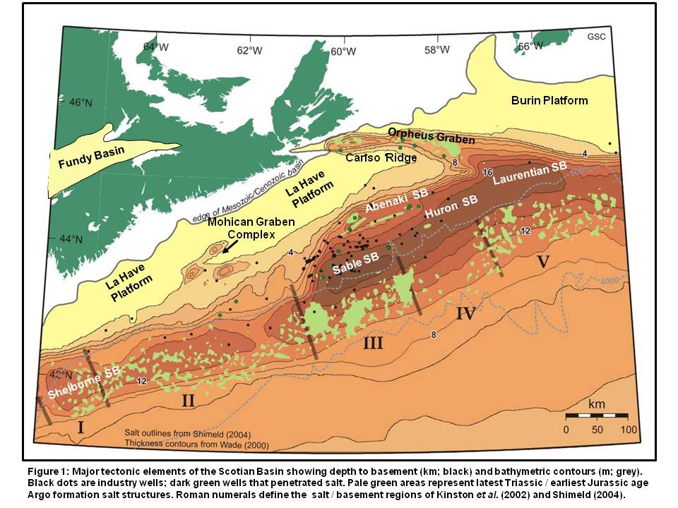
The Scotian Basin is located offshore Nova Scotia where it extends for 1200 km from the Yarmouth Arch / United States border in the southwest to the Avalon Uplift on the Grand Banks of Newfoundland in the northeast (Figure 1). With an average breadth of 250 km, the total area of the basin is approximately 300,000 km2. Half of the basin lies on the present-day continental shelf in water depths less than 200 m with the remainder on the continental slope in water depths from 200 to >4000 m.
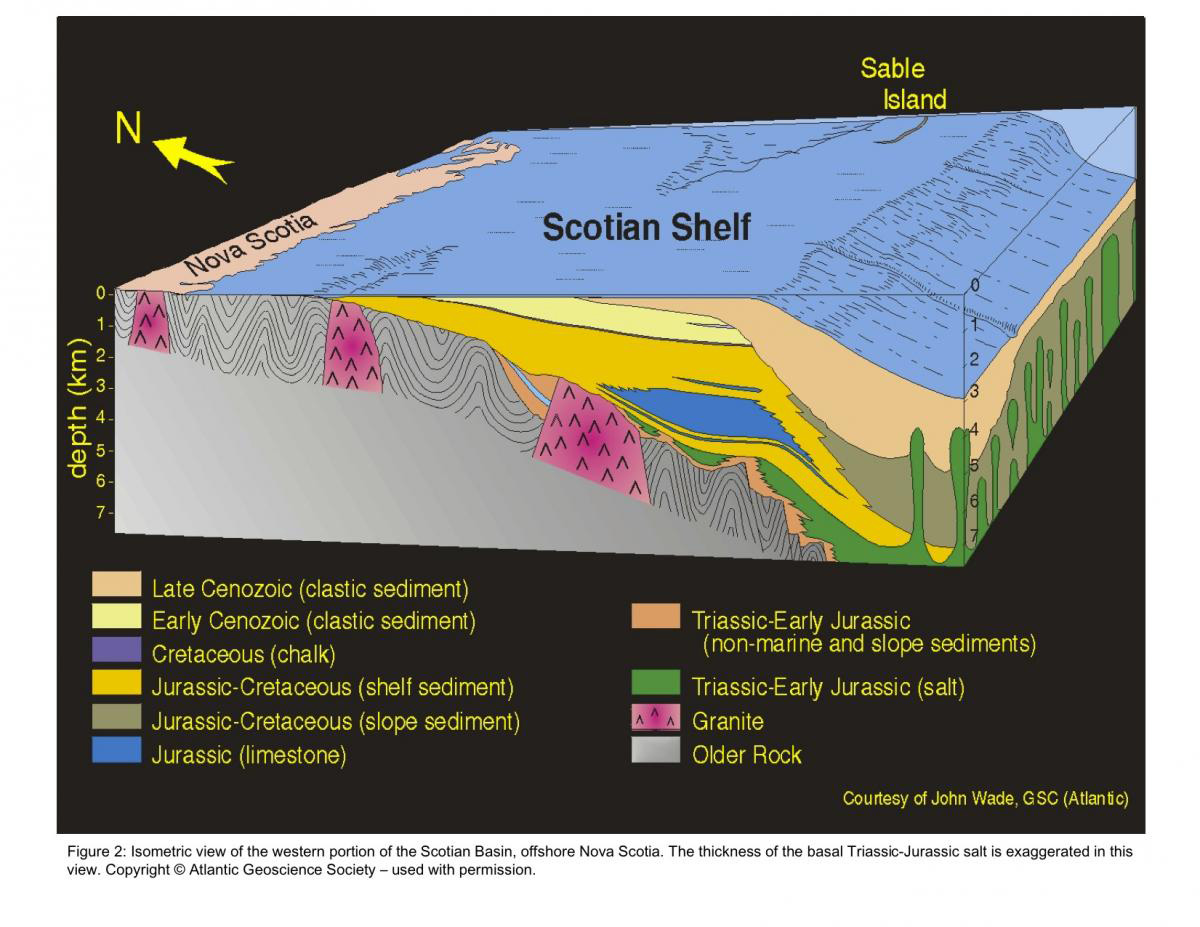
The Scotian Basin formed on a passive continental margin that developed after rifting and break up of northern Pangea separating North America from northwest Africa (Figure 2). It consists of a series of alternating "highs and lows", or platforms / ridges and depocentres. From the southwest to the northeast these are defined as the Shelburne Subbasin, La Have Platform, Mohican and Naskapi grabens, Sable, Abenaki and Huron Subbasins, Orpheus Graben and Laurentian Subbasin (Figure 1). The boundaries of these platforms and basins may have been defined by regularly-spaced northwest-southeast trending oceanic fracture zones that extended landward onto continental crust (Welsink et al. 1990). A northeast-southwest trending basement hinge zone is also present along the margin, defining the landward limit of maximum tectonic extension and an abrupt seaward increase in basement depth due to thermal subsidence (Figure 3). Together, these basement elements asserted a strong control on sediment distribution in the region for more than 190 million years.
Red beds and evaporates were the dominant depositional successions during the rift phase, whereas typical clastic progradational sequences with periods of carbonate deposition dominated the drift phase (Figure 4). Below is a summary of the synrift to postrift depositional settings in the Scotian Basin, based largely on results from Wade and MacLean (1990).
Synrift
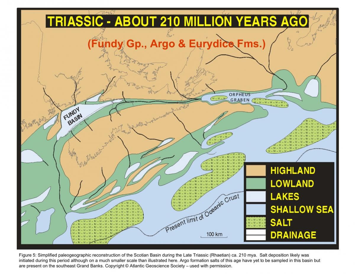
Rifting was initiated in the Middle Triassic period, about 225 million years ago (Mya). At that time, the Nova Scotia region occupied a near equatorial position, situated adjacent to Morocco, with most of its older Paleozoic rocks having direct Moroccan affinities. A series of narrow, interconnected fault-bounded basins separated by basement horsts were created during the rift phase and were filled with fluvial and lacustrine sediments as well as volcanic rocks (Fundy-type sequences). By the latest Triassic-earliest Jurassic, tectonic motion had moved the North American and African plates slowly northward, with the Nova Scotia-Moroccan region in an arid sub-equatorial climate zone (ca. 10-20°N paleolatitude). Renewed Late Triassic rifting of continental crust further to the north and east in the Grand Banks / Iberia region breached topographic barriers and permitted the first incursions of marine waters from the eastern Tethys paleo-ocean to flood into these interconnected synrift basins (Figure 5). Restricted, shallow marine conditions were established with some mixed clastic and minor carbonate sedimentation (Eurydice Formation).
Due to the hot and dry climate and sub-sea level elevations, the shallow seas underwent constant evaporation resulting in the precipitation of extensive salt and minor anhydrite deposits that probably exceeded two kilometers in thickness in the central parts of the rift system (Osprey and Argo Formations).
The west-dipping listric basement faults of the Mohican and Naskapi grabens are interpreted as the antithetic response to extension in the Fundy Basin during the Late Triassic (Wade et al. 1996). These grabens acted as loci for siliciclastic deposition for newly established fluvial drainage systems, with the source of the sediments from the current mainland region of Nova Scotia. An earliest(?) Jurassic phase of siliciclastic deposition that predates break-up is observed in the west-central part of the Scotian Basin inboard of the hingeline, and may exist elsewhere along the margin as well as the Moroccan conjugate. This eastward-directed pulse of redbed sediments (informally termed the Heracles Unit by some) conformably overlies and deforms Argo Formation evaporites in the Mohican Graben. While not yet encountered in wells or observed elsewhere along the margin, the age of this succession can be reasonably inferred as early Hettangian to perhaps mid- to late Sinemurian since it conformably overlies the Argo Formation and is later truncated by the younger Breakup Unconformity as described below.
Renewed tectonism in the central rift basin during the Early Jurassic (mid-Sinemurian?) is recorded by the complex faulting and erosion of Late Triassic and Early Jurassic sediments and older rocks. This phase of the rifting process resulted in the formation of a Breakup Unconformity (BU), which coincided with the final separation of the North America and Africa continents, the creation of true oceanic crust through volcanism, and opening of the proto-Atlantic Ocean. As a result of this event, the heavily faulted, complex terrane of grabens and basement highs along the Scotian margin underwent a significant degree on peneplanation.
Early Postrift
A marine transgression followed the BU in the Early Jurassic (approximately Sinemurian) eventually covering the basin with a narrow, shallow and restricted sea within which thin sequences of carbonate and clastic sediments accumulated. Transgressive shallow water to tidally influenced dolomites and clastics were laid down in localized areas on the seaward portion of the margin under slightly restricted marine conditions with marls and shales deposited in the distal region (Iroquois Formation). A thick succession of coarser grained clastic sediments and shales from fluvial sources (Mohican Formation) was deposited concurrently on the basin margins. The succession was sourced from adjacent high relief terranes and eventually prograded out over the margin to fill graben lows and bury basement highs by the early Middle Jurassic (Wade and MacLean, 1990). The fine muds from this succession were transported by marine processes into deeper water where they slowly infilled basinal lows and blanketed newly formed oceanic crust.
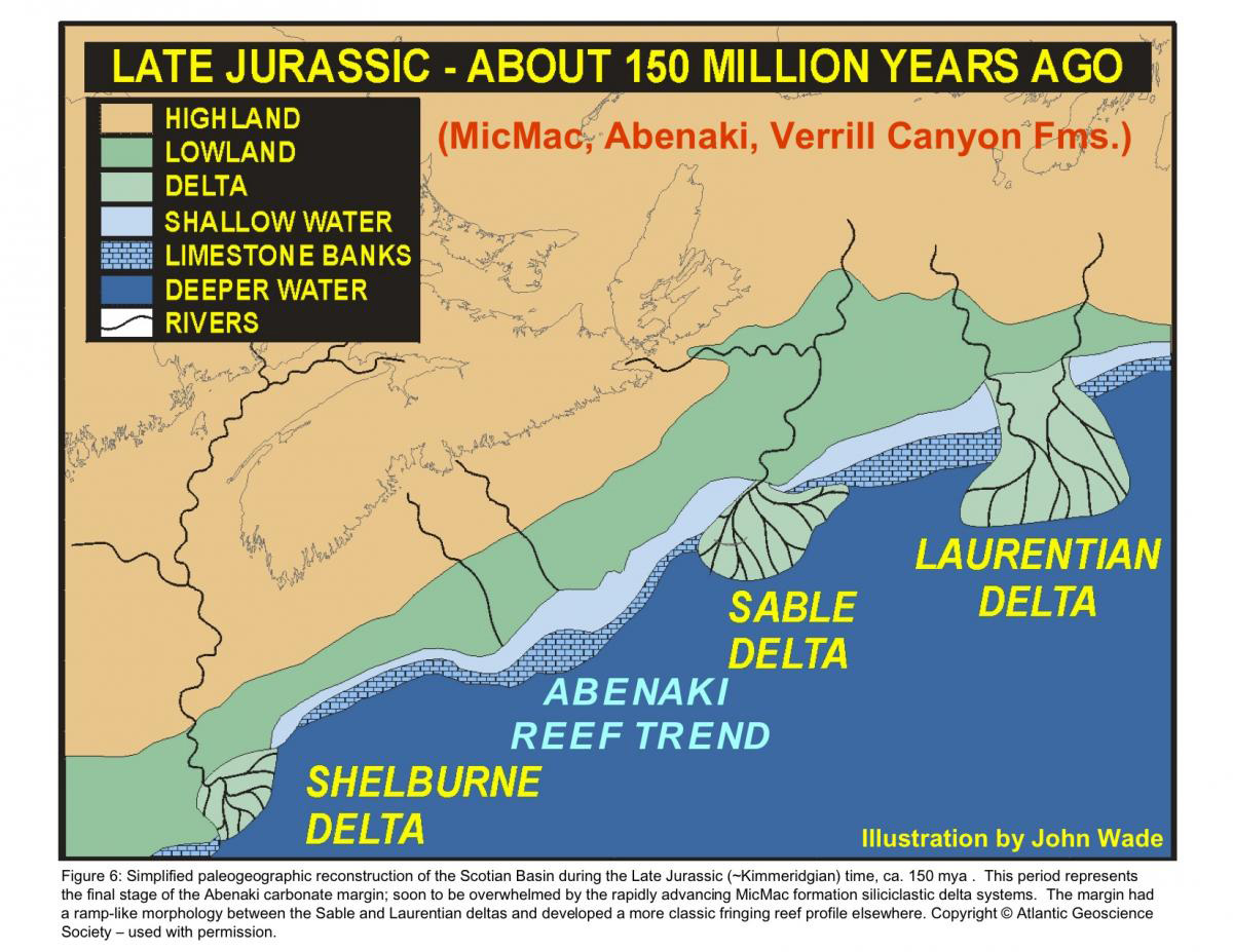
The combination of sea-floor spreading, basin subsidence and global sea level rise caused the Atlantic Ocean to become broader and deeper (~1000 m) by the Middle Jurassic. A prominent carbonate bank complex developed in the western part of the basin at this time and persisted until the latest Jurassic-earliest Cretaceous (Abenaki Formation) (Eliuk, 1978; Ellis et al. 1985) (Figure 6). Growth of the carbonate bank was tempered by Upper Jurassic and Lower Cretaceous deltaic progradational successions that locally overwhelmed carbonate sedimentation. The Abenaki Formation is subdivided into several members. A carbonate platform and margin succession was intitally established along the basin hinge zone (Scatarie Member) that prograded out into deeper waters where marls and clastic muds were deposited. Continuing margin subsidence coupled with global sea level rise in the Callovian resulted in deposition of transgressive marine shales that blanketed carbonates and other shelf sediments (Misaine Member). From the late-Middle to the end of the Jurassic, carbonate reef, bank and platform environments were established and thrived along the basin hinge line of the La Have Platform (Baccaro Member). Similar successions were formed on long, linear faulted basement ridges in the Abenaki and Huron Subbasins though are limited to the lower part of the Bacarro due to encroaching deltaic sedimentation from the northeast (Mic Mac Formation). Outboard and southeast of this region, a mixed Mic Mac-Abenaki carbonate-clastic ramp succession was deposited, and in deeper water a thinner succession of shales and limestones accumulated (roughly between by the J2 and J1 reflectors of Ebinger and Tucholke, 1988).
Concurrent with carbonate deposition, regional uplift in Atlantic Canada and Labrador resulted in an influx of clastic sediments and the establishment of the mixed energy (current and tidal) Sable Delta complex in the Laurentian Subbasin, and slightly later in the Sable Subbasin. In the southwest, a similar progradation occurred at an embayment in the vicinity of the U.S.-Canada border (Shelburne Delta). These sediments were primarily sourced from the adjacent thick (14+ km) blanket of latest Devonian to Permian sediments centred in the Gulf of St. Lawrence region that covered the entire Atlantic Provinces region, parts of New England, and Newfoundland and Labrador (Pe-Piper & Piper, 2004; Pe-Piper & MacKay, 2006; Li et al. 2012; Piper et al. 2012). The Mic Mac Formation records this first phase of delta progradation into these subbasins, represented by distributary channel and delta front fluvial sands cyclically interfingering with prodelta and shelf marine shales of the Verrill Canyon Formation or equivalent carbonates.
Late Postrift
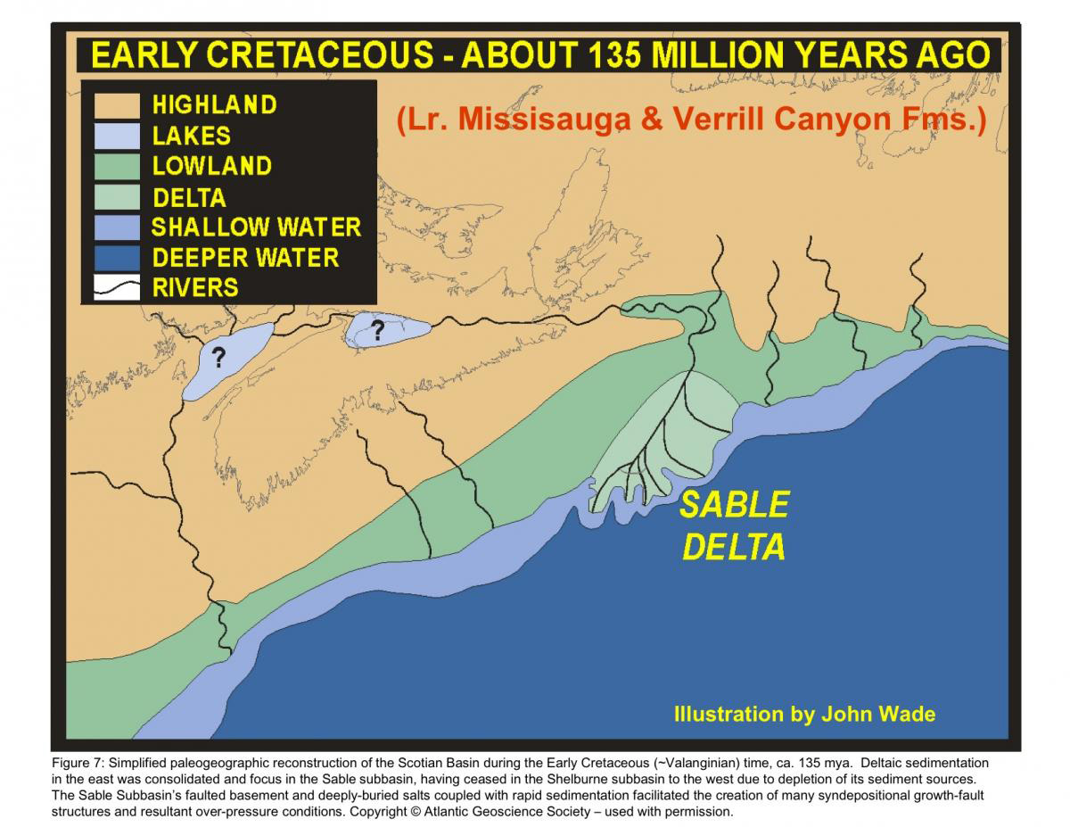
The ancestral St. Lawrence River was well established by the earliest Cretaceous, delivering increasing supplies of clastic sediments into the Scotian Basin that overwhelmed and buried the carbonate reefs and banks on the La Have Platform and later the Huron Subbasin. A series of thick sand-rich deltaic, strandplain and marine shelf successions (Missisauga Formation) dominated sedimentation throughout the Early Cretaceous (Figure 7). The Sable Delta prograded rapidly southwest into the Laurentian, Sable and Huron Subbasins, while in the Shelburne Subbasin the Shelburne Along the La Have Platform, small local rivers draining off of the southwest Nova Scotia mainland provided modest amounts of sands and shales to this region and associated deeper water realm, with a potentially more important source of fluvial deltaic clastics supplied along the southwestern most part of the margin where Lower to mid-Cretaceous(?) prograding clinoforms are recognized on seismic profiles (OETR, 2011).
Increasing deposition of Middle Jurassic and Cretaceous sediment along and to the south of the basement hinge zone loaded the salt, leading to the creation of seaward-dipping growth faults that acted as loci for sand accumulation. Deltaic sedimentation was interrupted along much of the Scotian margin by a late Early Cretaceous major marine transgression when the shelf was blanketed by thick shales of the Naskapi Member of the Logan Canyon Formation. Renewed deltaic and fluvial sedimentation in the Aptian-Cenomanian was periodically interrupted by marine transgressions (Cree and Marmora members) (Wade and MacLean, 1990). Sand was deposited along a broad coastal plain and shallow shelf though waned as sediment supply decreased from the lower relief hinterland. This was followed by deposition of marine shales (and some limestones) of the Dawson Canyon Formation.
In more distal settings, sediment loading of Argo salts created a slope with a complex and widely varying morphology (e.g. Kidston et al., 2002, 2007; Shimeld, 2004; Deptuck, 2011; Kendell, 2012) analogous to other basins with mobile salt substrates (e.g. Gulf of Mexico). In areas where sedimentation was high such as the Sable and possibly Shelburne deltas, salt moved both vertically and in the seaward direction forming canopies and related features. During periods of low sea level, extant rivers incised exposed outer shelf sediments, with shelf-edge deltas (Cummings & Arnott, 2005; Cummings et al., 2006) supplying coarser grain sediments to the continental shelf edge. Turbidity currents carried mixed clastics into deeper water, with increased potential for trapping of turbidite sands because of the undulating morphology of the upper and middle slope seaward of the Sable Subbasin in the Cretaceous (e.g. CNSOPB, 2008, 2011, 2012; Kendell, 2012). The Cretaceous slope along the southwestern part of the margin, in contrast, was dominated by sediment bypass (e.g. Deptuck, 2011; CNSOPB 2011, 2012; Deptuck & Campbell, 2012) across a region referred to as the ‘slope detachment province’. Deptuck (2011) noted the increased potential for trapping of turbidite sands seaward of this area (on the lower continental slope and rise), where the most prominent minibasins and salt structures are recognized above the thickest (and now most heavily subsided) parts of the primary salt basin.
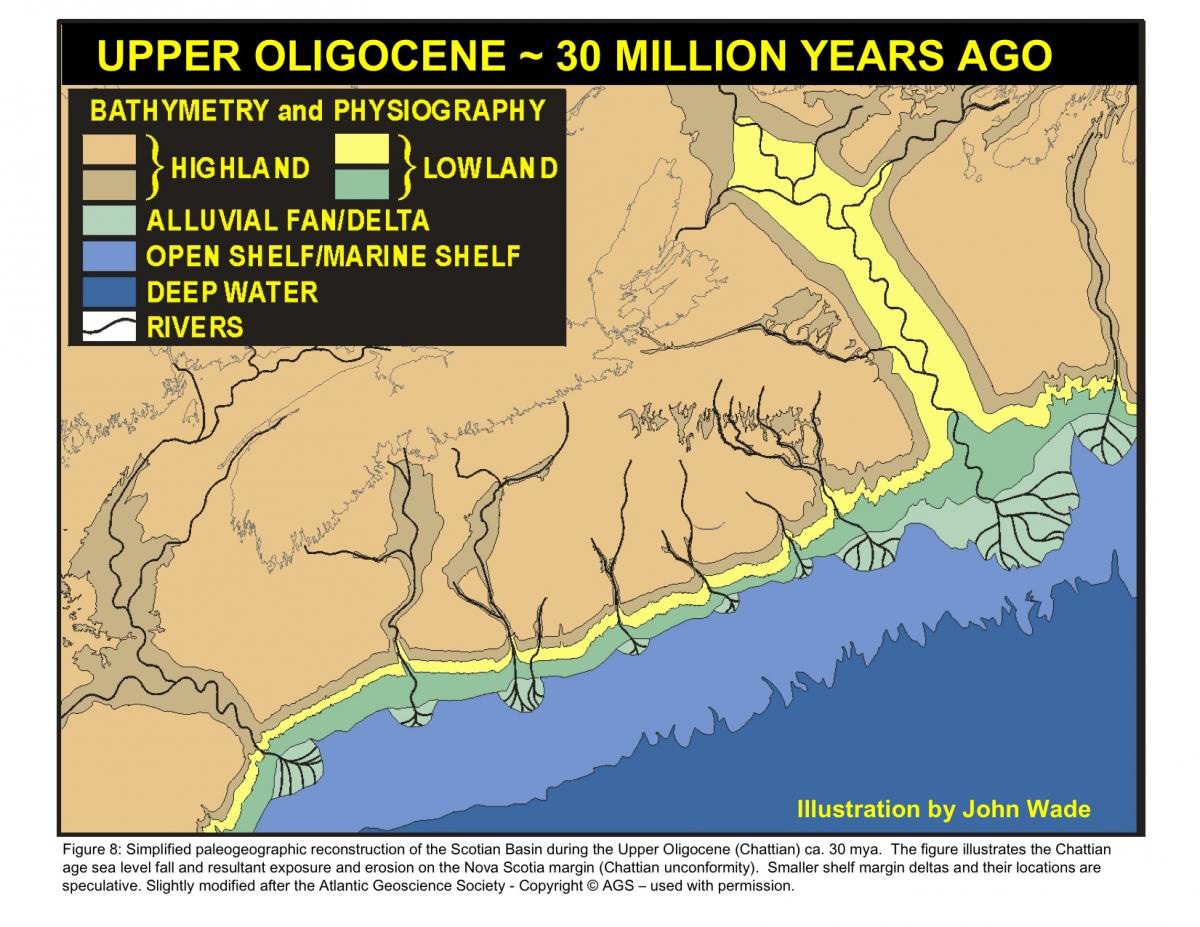
The end of the Cretaceous period in the Scotian Basin saw a rise in sea level and basin subsidence and deposition of marine marls and chalky mudstones of the Wyandot Formation. These were later buried by Upper Cretaceous and lower Tertiary deltas with sand prone topsets (e.g. Fensome et al., 2008; Smith et al. 2010) that eventually gave way to Tertiary marine shelf mudstones of the Banquereau Formation (Figure 8). Several major Tertiary unconformities are recognized that, with the exception of an Early Eocene unconformity associated with the ~51 Ma Montagnais bolide impact (Deptuck and Campbell, 2012), are presumed to be associated with lowstands in sea level. Unconsolidated strata on the shelf were eroded and transported into deeper water where active western boundary ocean currents swept the margin, depositing widespread contourites that interfingered with sediments deposited from down-slope processes (e.g. Campbell, 2011; Campbell and Deptuck, 2012). During the Quaternary Period of the last 2 million years, several hundred metres of glacial and marine sediments were deposited on the outer shelf and slope as glaciers periodically advanced and retreated across the shelf (e.g. Piper et al., 2012).
REFERENCES
Campbell, D.C., 2011
The Late Cretaceous and Cenozoic geological history of the outer continental margin off Nova Scotia, Canada: Insights into margin evolution from a mature passive margin.
PhD Dissertation, Department of Earth Sciences, Dalhousie University, Halifax, Nova Scotia
Canada-Nova Scotia Offshore Petroleum Board, 2012
Call for Bids NS12-1 Information Package.
http://www.callforbids.cnsopb.ns.ca/2012/01/
Canada-Nova Scotia Offshore Petroleum Board, 2011
Call for Bids NS11-1 Information Package.
http://www.callforbids.cnsopb.ns.ca/2011/01/
Canada-Nova Scotia Offshore Petroleum Board, 2008
Call for Bids NS08-2 Information Package.
http://www.callforbids.cnsopb.ns.ca/2008/02/
Cummings, D.C. and Arnott, R.W.C., 2005
Growth-faulted shelf-margin deltas: a new (but old) play type, offshore Nova Scotia.
Bulletin of Canadian Petroleum Geology, vol.53, no.3, p.211-236.
Cummings, D.C., Hart, B.S. and Arnott, R.W.C., 2006
Sedimentology and stratigraphy of a thick, areally extensive fluvial-marine transition, Missisauga Formation, offshore Nova Scotia and its correlation with shelf margin and slope strata.
Bulletin of Canadian Petroleum Geology, vol.54, no.2, p.152-174.
Deptuck, M.E., 2011
Proximal to distal postrift structural provinces on the western Scotian Margin, offshore Eastern Canada: Geological context and parcel prospectivity for Call-for-Bids NS11-1.
Canada-Nova Scotia Offshore Petroleum Board, Geoscience Open File Report (GOFR) 2011-001MF, 42p.
Deptuck, M.E. and Campbell, D.C., 2012
Widespread erosion and mass failure from the ~51 Ma Montagnais marine bolide impact off southwestern Nova Scotia, Canada.
Canadian Journal of Earth Sciences, vol. 49, no.12, p.1567-1594.
Campbell, D.C. and Deptuck, M.E. 2012
Alternating bottom-current-dominated and gravity-flow-dominated deposition in a lower slope and rise setting – insights from the seismic geomorphology of the western Scotian margin, eastern Canada
In: B. Prather, M. Deptuck, D. Mohrig, B. van Hoorn, and R. Wynn (Eds.), Application of the Principles of Seismic Geomorphology to Continental Slope and Base-of-slope Systems: Case Studies from Seafloor and Near-Seafloor Analogues: SEPM Special Publication 99, p. 329-346.
Eliuk, L.S., 1978
The Abenaki Formation, Nova Scotia Shelf, Canada - A depositional and diagenetic model for a Mesozoic carbonate platform.
Bulletin of Canadian Petroleum Geology, vol.26, no.4, p.424-514.
Ellis, P.M., Crevello, P.D. and Eliuk, L.S., 1985
Upper Jurassic and Lower Cretaceous deep-water buildups, Abenaki Formation, Nova Scotian Shelf.
In: P.D. Crevello and P.M. Harris (Eds.), Deep-water Carbonates. Society of Economic Paleontologists and Mineralogists Special Publication 25, p.249-261.
Kendell, K.L., 2012
Variations in salt expulsion style within the Sable Canopy Complex, central Scotian margin.
Canadian Journal of Earth Sciences, vol. 49, no.12, p.1504-1522.
Kidston, A.G., Brown, D.E., Smith B.M. and Altheim, B., 2002
Hydrocarbon Potential of the Deep-Water Scotian Slope.
Canada-Nova Scotia Offshore Petroleum Board, Halifax, 111p.
http://www.cnsopb.ns.ca/sites/default/files/pdfs/Hydrocarbon_Potential_Scotian_Slope.pdf
Kidston, A.G., Smith, B., Brown, D.E., Makrides, C. and Altheim, B., 2007
Nova Scotia Deep Water Offshore Post-Drill Analysis – 1982-2004.
Canada-Nova Scotia Offshore Petroleum Board, Halifax, Nova Scotia, 181p.
http://www.cnsopb.ns.ca/sites/default/files/pdfs/Deep_Water_Post_Drill_Analysis_2007.pdf
Li, G., Ravenhurst, C.E. and Zentilli, M., 1995
Implications of apatite fission track analysis for the thermal history of the Scotian Basin, offshore Nova Scotia, Canada.
Bulletin of Canadian Petroleum Geology, vol.43, no.2, p.127-144.
Piper, D.J.W., Pe-Piper, G., Tubrett, M., Triantafyllidis, S. and Strathdee, G., 2012
Detrital Zircon geochronology and polycyclic sediment sources, Upper Jurassic – Lower Cretaceous of the Scotian Basin, southeastern Canada.
Canadian Journal of Earth Sciences, vol. 49, no.12, p.1540-1557.
Piper, D.J.W., Deptuck, M.E., Mosher, D.C., Hughes-Clarke, J.E., and Migeon, S., 2012 Erosional and depositional features of glacial meltwater discharges on the eastern Canadian continental margin.
In: B. Prather, M. Deptuck, D. Mohrig, B. van Hoorn, and R. Wynn (Eds.), Application of the Principles of Seismic Geomorphology to Continental Slope and Base-of-slope Systems: Case Studies from Seafloor and Near-Seafloor Analogues: SEPM Special Publication 99, p. 61-80.
Pe-Piper, G. and MacKay, R.M., 2006
The Provenance of Lower Cretaceous sandstones onshore and offshore Nova Scotia from electron microprobe geochronology and chemical variations of detrital monazite.
Bulletin of Canadian Petroleum Geology, vol.54, no.4, p.366-379.
Pe-Piper, G. and Piper, D.J.W, 2004
The effects of strike-slip motion along the Cobequid-Chedabucto-southwest Grand Banks fault system on the Cretaceous-Tertiary evolution of Atlantic Canada.
Canadian Journal of Earth Sciences, vol.41, no.7, p.799-808.
Shimeld, J. 2004
A comparison of salt tectonic subprovinces beneath the Scotian Slope and Laurentian Fan.
24th Annual GCS-SEPM Foundation Bob F. Perkins Research Conference, Houston, p.502-532, CD-ROM.
Wade, J.A. and MacLean, B.C., 1990
Chapter 5 - The geology of the southeastern margin of Canada, Part 2: Aspects of the geology of the Scotian Basin from recent seismic and well data.
In: M.J. Keen and G.L. Williams (Eds.), Geology of Canada No.2 - Geology of the continental margin of eastern Canada. Geological Survey of Canada, p.190-238 (also Geological Society of America, The Geology of North America, Vol.I-1).
Welsink, H.J., Dwyer, J.D. and Knight, R.J., 1990
Tectono-Stratigraphy of Passive Margin off Nova Scotia.
In: A.J. Tankard and J.R. Balkwill (Eds.), Extensional Tectonics and Stratigraphy of the North Atlantic Margins. American Association of Petroleum Geologists, Memoir 31, p.215-231.


