

Western Scotian Margin
- Introduction and scope
- First-order Structural Subdivisions
- :: LaHave Platform Province
- :: Slope Detachment Province
- :: Allochthonous Salt and Minibasin Province
- :: Outer ECMA Province
- Discussion and Summary
- Figures
NS11-1 Parcel Prospectivity
Location and Coordinates
Geoscience References

Western Scotian Margin
Discussion and Summary
The postrift deformation styles in the four structural provinces defined in this study were probably controlled by variations in the style and magnitude of postrift basement subsidence, preconditioned in part by the distribution of salt in the synrift autochthonous salt basin.
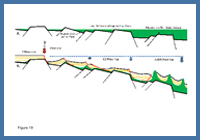
FIGURE: 19
Sketch showing interpreted a) pre-breakup configuration of margin, with thickest synrift salt accumulating in the ASM province where maximum rift subsidence is inferred to have taken place; b) Early postrift configuration with detachment of Jurassic strata in response to hinge zone development and thermal subsidence. SD province was tilted seaward during this time, whereas the ASM province may have subsided more uniformly. Contractional structures in the proximal parts of the ASM province develop in response to up-slope extension due to gravity gliding.
Sketch showing interpreted a) pre-breakup configuration of margin, with thickest synrift salt accumulating in the ASM province where maximum rift subsidence is inferred to have taken place; b) Early postrift configuration with detachment of Jurassic strata in response to hinge zone development and thermal subsidence. SD province was tilted seaward during this time, whereas the ASM province may have subsided more uniformly. Contractional structures in the proximal parts of the ASM province develop in response to up-slope extension due to gravity gliding.
The LP province for the most part formed a stable slowly subsiding continental platform that accommodated up to four km of Jurassic, Cretaceous and Cenozoic strata dominated by non-marine to outer neritic depositional environments. In contrast, the SD province experienced significant asymmetric subsidence causing rifted basement and the overlying autochthonous salt basin to flex and tilt seaward of a prominent postrift hinge zone. The onset of postrift subsidence decoupled the deformation styles above and below the autochthonous salt layer. The widespread thin-skinned detachment (gravity gliding) of cover strata and associated raft tectonics are therefore a product of this seaward tilt. Where imaging allows, the SD province coincides with, and may form a useful proxy for, the area of most rapidly thinning continental crust away from the hinge zone. Subsidence in the distal parts of the SD province, where the crust was most attenuated, brought the top of the autochthonous salt basin (that at break-up was presumably close to or just below sea level) down to present day depths greater than 7-8 km, compared to just 3-4 km in the LP province.
In contrast to the SD province, postrift deformation in the ASM province was dominated by expulsion of allochthonous salt bodies, and postrift subsidence must have taken place relatively uniformly, such that down-building and passive loading of salt dominated (Albertz et al. 2010). Tilting of the ASM province was probably less important given the limited amount of seaward-leaning salt bodies, and lack of significant salt expulsion beyond the seaward limit of the autochthonous salt basin (see Albertz et al. 2010), perhaps with the exception of the area near the Shelburne Canopy. Some salt presumably flowed seaward from the SD province towards the ASM province while the margin subsided, but it is difficult to know the extent to which this happened.
The outer ECMA province, if it corresponds to subaerial volcanics, would define a terrestrial boundary on the seaward side of a newly formed shallow marine basin. It is also possible that the short-term delay in subsidence caused by these subaerial volcanics could have allowed salt to continue accumulating for a short time after break-up (Jackson et al. 2000). However, when this volcanic wedge ultimately subsided below sea level, and true oceanic crust formed, the outer ECMA province ultimately sank 8 to 9 km to its present position. In terms of salt tectonics, the outer ECMA province is a region where localized salt tongues overhang Jurassic and Cretaceous strata in the northeast and a more significant salt canopy (Shelburne Canopy) flowed across Jurassic strata to the southwest (Figures 1, 15b). Emplacement of subaerial volcanics would also have loaded the autochthonous salt layer along the seaward boundary of the ASM province as it split the original salt basin.
Why are there so few allochthonous salt bodies in the SD province?
Two end-member scenarios could explain the paucity of allochthonous salt diapirs in the SD province compared to the ASM province. Autochthonous salt could have been expelled from the SD province towards the ASM province, thereby increasing the volume of salt and the propensity for diapirism (Scenario 1). This could have been accomplished through sediment loading in the SD province causing salt expulsion (Scenario 1a) or regional tilt of the top salt surface causing autochthonous salt to flow from the SD province to the ASM province (Scenario 1b). The latter mechanism is gravitationally driven and does not necessarily require sedimentation so long as salt has enough time to flow (see Albertz et al. 2010).
Alternatively, the lack of allochthonous diapirs over much of the SD province could simply reflect regional variations in the original depositional thickness of autochthonous salt, with more salt originally accumulating in the ASM province (Scenario 2). The amount of synrift subsidence combined with offsets along transfer faults (Welsink et al. 1989) may have strongly influenced where the thickest synrift salt could accumulate.
Scenario 1a seems unlikely everywhere except perhaps outboard the Mohican Graben, where Early to Middle Jurassic sediments are thicker, Scenario 1b is more difficult to evaluate and it is possible that some salt flowed seaward from the SD province towards the ASM province in the Early Jurassic. This scenario would require an initial period of salt inflation followed later by sediment loading to form the ASM province.
The preferred interpretation is that the paucity of allochthonous salt diapirs over much of the SD province reflects the original depositional thickness of autochthonous salt (Scenario 2), with only minor amounts of salt flowing generally only a few km from the seaward most part of the SD province (Figure 19).
In this scenario, the landward limit of the ASM province would approximately define the seaward transition into thicker autochthonous salt. The true transition probably corresponds more closely to the chain of sub-circular minibasins that form just inboard the ASM province, from which the most proximal allochthonous salt bodies were expelled. The landward limit of allochthonous salt bodies appears to shift in a stepwise manner from west to east (Figure 13c), and offsets of these basins by synrift transfer faults may ultimately be responsible for this pattern. Within the ASM province, segmentation of the autochthonous salt basin along transfer faults, combined with the underlying rugose synrift fabric between transfer faults (rugosity is inferred but not generally observed below the ASM province because of poor imaging), could have influenced the orientation of salt bodies.
Although diapir growth along much of the ASM province probably took place during passive loading (Albertz et al. 2010), there is also clear evidence for Jurassic and Cretaceous shortening resulting in fold growth, particularly along the landward parts of the ASM province (Deptuck et al. 2009; Deptuck 2010a). Increased shortening in the areas immediately down-slope from a region of thin-skinned extension may also have enhanced diapir formation in the ASM province.
Finally, increased rift accommodation below the ASM province opens up some intriguing opportunities for other synrift to postrift marine deposits to have accumulated, including potential source rocks, but improved seismic imaging below the salt is needed to evaluate this.